



Every month Yachting Monthly's resident expert, Rachael Sprot take on a YM readers question. This month tackling a drying channel
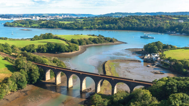
Tim and Josh have found a space for their Bowman 40, Artemis, which has a 1.5m draught, at Treluggan Boatyard which is five miles off the Tamar up the River Lynher.
The difficulty is that the river completely dries for the last three miles and doesn’t appear to have any formal buoyage (there is mention of some withies and posts). The lift-out has been scheduled for 1630, an hour and a half before HW Springs.
The yard manager assures them they’ll be able to negotiate the river at this time and has sent them some pilotage instructions, but they’ve checked the charts and aren’t so sure. Navionics shows a relatively wide channel with drying heights of around 2m.
The Imray chart uses a single line to depict the deepest part of the river (which corresponds with the yard’s instructions), but crosses a drying height of 3.3m.
They’d be making their passage with a height of tide of 4m so if the Navionics chart is correct, they’ll make it up but according to the Imray chart, they won’t. What should they do?
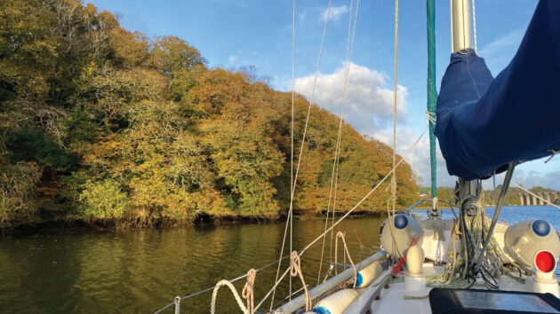
Navigating a drying channel when the charts disagree
AThis question is really about how to navigate in areas with limited navigational data. Tom and Josh have identified a discrepancy between three sources of information – the Navionics and Imray charts, and the yard manager – which is a good indicator that the charts here are a guide, not gospel. When they visited the yard there were plenty of boats with similar draughts ashore, albeit most of them were smaller than a Bowman 40.
Tim and Josh need as much information as they can get to try and identify the run of the channel. I would be suspicious of the wide channel shown by Navionics – usually the top of a muddy river has a narrow deep-water channel surrounded by steep mud banks, which corresponds more closely with the Imray chart and the advice from the yard manager.
In the upper reaches of rivers, extra information might include Google Maps (with any luck, satellite view may show the river at low water), drone footage from YouTube, and even OS maps, which can be a good indicator of the baseline of the riverbed.
Owing to the lack of reliable chart data, they need to be prepared for a minor grounding. Occasionally touching the edge of a mudbank at slow speed in a heavy, long-keeled yacht like a Bowman 40, would, in my mind, carry low risk of damage.
Article continues below…
What to do if someone anchors too close to your boat?
Clara, Fi and Ahmed are cruising north Brittany on Clara’s Rival 34, Grace. Clara is a recently-qualified Coastal Skipper, and…
How to deal with a prop wrap
Sadler 29, Nimbus, is on passage from North Shields to Grimsby when the engine falters and cuts out. Skipper, Tim,…
If they were doing this trip frequently in a lightweight yacht with a fin keel this would be different. They need to monitor the echosounder constantly and keep speed to a minimum.
Less likely, but worth considering, would be a full stranding. This is best avoided by approaching with plenty of flood tide remaining to float off. An hour and a half before high water means there’s over a metre of tide left to rise, which should be plenty to get them out of a tricky situation.
However, I wouldn’t de-rig the deck in readiness for the haul out – the anchor needs to be ready to go and dinghy available, plus a headsail rigged which could be partially unfurled (and even backed) to induce a heel if necessary.
Carrying warm clothes and a few basic stores on board is always sensible; you never know quite how things might turn out.
Finally, I would set a snail trail with a high-resolution track on the plotter or a navigation app (Navionics does this very well), to help with getting out again when they relaunch. If they note the height of tide at the time of the minimum reading on the echosounder, they’ll be able to calculate how much height of tide they need for the departure.
Sometimes a low water dinghy expedition can be useful, but with over 2 miles of drying approach channel they’d need to time this well and to have a reliable outboard. If they do go ahead with a dinghy, a navigation app recording their track will be their best guide when they come in by yacht, though planting a withy or two would be the traditional way.
Although they have a modest draught, in my opinion a Bowman 40 is on the limits for this sort of creek-crawling venture. It’s a heavy boat to manage if they do go aground, and backing sails, rowing out anchors and inducing heel all become more arduous. However, with careful pilotage this is unlikely, and once they’re in, the yard is supremely sheltered so it’s a good place to overwinter.
Enjoyed reading this?
A subscription to Yachting Monthly magazine costs around 40% less than the cover price, so you can save money compared to buying single issues.
Print and digital editions are available through Magazines Direct – where you can also find the latest deals.
YM is packed with information to help you get the most from your time on the water.
-
-
- Take your seamanship to the next level with tips, advice and skills from our experts
- Impartial in-depth reviews of the latest yachts and equipment
- Cruising guides to help you reach those dream destinations
-
Follow us on Facebook, Twitter and Instagram.
Note: We may earn a commission when you buy through links on our site, at no extra cost to you. This doesn’t affect our editorial independence.