


Jamming and spoofing GPS signals is now rife in certain parts of the world, but there are ways for cruisers to survive unscathed
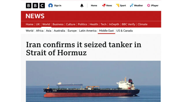
About three weeks before US/Israeli bombing of Iran began, Euronews.com published a fairly low-key report online about a US tanker: ‘The Stena Imperative was approached by three pairs of small armed boats belonging to Iran’s Revolutionary Guards while transiting the Strait of Hormuz, approximately 30km north of Oman.’
The ship resisted seizure and was escorted to safety by the US Navy. An earlier incident took place in November 2025. The BBC reported that The Talara, a tanker sailing under the flag of the Marshall Islands, was travelling from the United Arab Emirates (UAE) to Singapore when it was seized by Iran’s Islamic Revolutionary Guard Corps (IRGC). The IRGC said it was found to be ‘in violation of the law by carrying unauthorised cargo’, but did not explain the violation.
I was sent these two reports by Ramsey Faragher, Director and CEO of the Royal Institute of Navigation (RIN) accompanied by the alarming short message: ‘There has been speculation that Iran may have used spoofing at times to make vessels believe they were still outside Iranian waters when they had actually entered them.’
At the RIN Electronic Navigation Conference held at Trinity House just a few days after the Stena Imperative incident, Faragher spoke in detail about the problems facing shipping and air traffic due to GPS interference in the Straits of Hormuz and the eastern Baltic. But he also issued some stark warnings for cruising sailors and the leisure marine industry about the necessity to take this issue seriously…
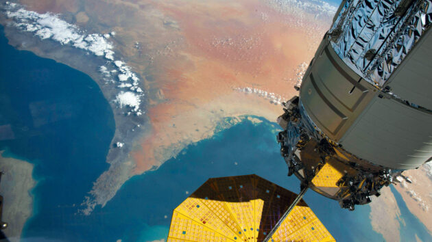
Tankers have been led astray and then seized with the aid of GPS jamming and spoofing.
Leisure vessels, though not the target, can also be caught out in affected in areas
Signal jamming and spoofing
‘Merchants and sea captains banded together, not too far from here and brought a petition to the British Parliament to solve the longitude problem. The government paid attention and offered the healthy reward of £20,000 to anyone who could solve the problem. The Longitude Act was issued on July 8, 1714 for a method to solve the longitude to an accuracy of half a degree. A very famous piece of history that I’m sure we’re all very aware of…
‘But we are in the middle of a new longitude problem today. That problem 300 years ago was one very much of bad physical weather and real fog and clouds. This problem is one of electronic fog and intentional disruptions to our navigation systems, and certainly the prize for solving this is worth a hell of a lot more than £20,000 pounds today.
‘Last year [2025] there were two groundings and one collision due to GNSS interference. The sum total of those three incidents will come close to about $100m when you count up all of the costs of salvaging the repairs, the loss of cargo, the delays to cargo, and all of those sorts of issues. So it’s a very expensive problem that needs solving. And I’ll try and get across quickly why it’s important to this particular community [leisure mariners], as well as to the bigger ships.’
The UAE port of Fujairah, near the Straits of Hormuz. Photo: Justin Kase z12z / Alamy Stock Photo
What is signal jamming?
Four separate satellites are required to provide an accurate position for a device on or near the earth’s surface. Civilian signals are transmitted in a bandwidth called L1 (1575.42 MHz), so in order to jam that signal and render GPS inaccessible, a device that drowns out that signal needs to start broadcasting on that frequency instead.
‘What happens in these aggressive interference regions is that there’s high powered jamming that denies your visibility of the true satellites,’ says Faragher by phone a few weeks after the conference.
‘And then there’s a spoofing signal kind of poking up above that noise even louder, and what that means is receivers get jammed first, they lose all the true signals, and they go back into what’s called an acquisition mode where they search blindly looking for things that look like the signals. And then when they lock onto those, they download the data from them and start using them.
‘And unfortunately, the vast majority of current generation receiver designs, which were never designed to work in aggressive electromagnetic warfare environments, just believe whatever they’re told when they’re in this acquisition mode. If the spoofing signals are making out the vessel is now in a completely different place, at a different time, they just believe it and jump there.’

Dr Ramsey Faragher (right), chief executive officer for the Royal Institute of Navigation (RIN)
Why does it matter?
A significant proportion of YM readers would be able to navigate across a large body of water without needing GPS, especially considering that the apps that can assist with sun sight declinations are not affected by electronic warfare (so far). And the same is true for the community of master mariners at the helm of the world’s shipping fleets. However, the problem that keeps Faragher and his fellow PNT (Position Navigation and Time) community members up at night is the proliferation of GPS-enabled features throughout the marine industry.
Critical impact on safety at sea
‘This is not primarily a navigation problem. We have lots of ways of navigating without GNSS (Global Navigation Satellite System). This is a safety problem and a cybersecurity problem. It does not matter how good you are with a sextant if one of your passengers falls overboard wearing an AIS SART (Search and Rescue Transponder),’ says Faragher. ‘Your sextant skills will not help them if the spoofing that’s going on in that region puts them in entirely the wrong part of the world.’
Faragher lists chartplotters, EPIRBs, DSC radio, MOB systems, satellite communications (satphones), autopilot and AIS as systems that affect both shipping and yachting that would be vulnerable to GNSS spoofing. Many of the systems could be made to work normally even without a GPS fix (some obviously could not), but the software would need redesigning with that in mind.
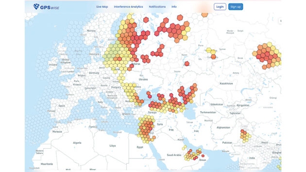
Websites such as gpswise.aero, pictured, use airline locator beacons to deduce whether GPS interference is high, medium or low in any given location. Photo: www.gpswise.aero
Faragher then gives the example of the humble Navtex, ‘a system that gives you weather warnings and other information via a very old technology that’s been around for a very long time. But you can buy ones today that will stop working in GNSS interference regions if you buy the premium model, because the premium model has a GNSS receiver in it.
‘It doesn’t need to be in there, but we’ve got ourselves into a situation where it’s seen as a benefit to add GPS into things that shouldn’t need GNSS in order to work. All it’s done is create cybersecurity vulnerability in yet another system onboard.
‘Why is the oily water separator [on large ships] needing GNSS? It’s all to do with time. A lot of this is to do with how different systems on a modern digital platform can be synchronised using timing information or get time to use within their software from somewhere else, and unfortunately that somewhere else can be a GNSS receiver.’
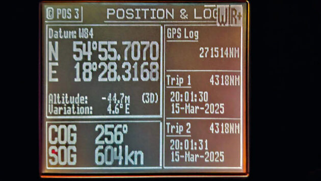
A photograph taken within a GNSS interference region showing a GNSS receiver display on the bridge reporting impossible speed (SOG – speed over ground) and altitude readings. Photo: Royal Institute of Navigation
Urgent recommendations
The RIN report Impacts of GNSS interference on maritime safety published in January 2026 made use of a wide-ranging questionnaire filled out by commercial shipping companies.
‘Across the survey we had 20 incidents reported of physical harm to personnel in interference regions, 19 incidents of property being damaged, and 10 instances of the environment being damaged,’ Faragher continues. ‘More than 10% of the respondents said that they had been led into unsafe or unlawful situations due to GNSS interference.
‘From your system’s point of view, when time gets passed around your vessel, a spoofer can intentionally transmit very far into the future or very far into the past. A lot of the failures that are being reported over there on the survey would have been incidences where time was simply completely wrong, a line of code errored and the system stopped working properly.
‘One of the most urgent recommendations of the report,’ says Faragher, ‘is addressing this particular problem and trying to rapidly solve the issue of safety when it comes to equipment that’s relying on open, unencrypted, unauthenticated GNSS signals, and ensuring that vessels that are going into known interference regions have adequate safety equipment on board that will not be vulnerable to these sorts of problems.’

Satellite signals can be drowned out by jammers on the earth’s surface
Where is this happening?
There are several useful resources online that indicate where signals are being jammed most actively. For mariners, the eastern Baltic and the Strait of Hormuz are the most relevant areas highlighted in red at gpswise.aero and gpsjam.org, although the eastern shore of the Med and the Black Sea are also badly affected. Russia and Iran would seem to be the most active jammers, but there are also red areas over Kashmir and the under-reported battle going on between Thailand and Cambodia over a border dispute.
‘It can also be used to cover up drug smuggling, illegal fishing and ship-to-ship transfers to break sanctions,’ says Faragher. The online data comes from the publicly available ADS-B aircraft beacon information, which needs a bit of adjustment to be applied to sea-level activities.
As a general rule of thumb, the radio horizon effect limits the transmission of jamming signals at sea level to about 80 miles, but at 37,000ft altitude, where aircraft fly, that interference radius is magnified significantly.
The reality of electronic warfare
‘Taking a look at gpswise.aero at the moment, there is a big red patch in a certain geographical region, which is how it appears from 37,000ft. Down at sea level, those red circles around the source of interference would be much smaller.’
The appearance of these websites in early 2022 brought home the reality of electronic warfare already affecting areas of the globe.
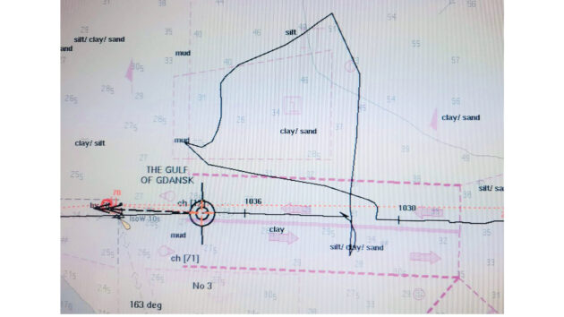
A photograph of a chart display taken during GNSS spoofing in the Baltic Sea that shows the vessel travelling in an extended looping journey over several minutes that the vessel did not really take. This may have been an intentional spoofed track being broadcast by the bad actor, or it may have been the effect of the GNSS receiver struggling to process a mixture of real and spoofed signals. Photo: Royal Institute of Navigation
‘There’s always been concerns in the navigation community about the risks of people putting jammers up on tall buildings just to cause trouble,’ says Faragher.
‘The UK hasn’t been badly affected, but in some parts of the world, these jammers have been on permanently now for more than four years. Some of the Baltic states and countries in the Middle East have been dealing with this every day for several years now.’
What is the solution?
Is there a simple solution for leisure craft to protect against jamming and spoofing in those regions where the practice is rife? ‘There are lots of solutions, short, medium, and long term [but] I’m afraid at the moment that the best solution is not to use it [GPS] in those regions,’ says Faragher.
Referring to the report compiled by RIN prior to the conference, Faragher revealed that in answer to the question: ‘How did you confirm that your systems had returned to normal?’ shipping captains and crew mentioned using a celestial fix, depth-sounders and alternative comms systems. But the top two answers were to look for another GNSS fix and to use radar positioning.
While he agreed that using radar overlaid on a digital chart is a good way of verifying your position, he warns: ‘Sometimes the radars themselves can lose features and lock up, so that’s something we want people to be aware of. The radar might need to be reset in the interference regions. We do not encourage using a different GNSS receiver to confirm where you are, because if one of your GNSS receivers is looking a bit funny in a region of intentional GNSS interference, you should assume all GNSS systems are under threat.’
Another solution Faragher mentioned at the RIN conference was CRPAs (Controlled Radiation Pattern Antennas), which used to be controlled under export regulations but are now available on the open market. They work by recognising the direction of the signal: if they detect a powerful signal from the horizon, they know it’s not from a satellite, so they steer an electronic null in that direction to stop the noise flooding in and overpowering the real signal from space.
But there are limitations: ‘One of the challenges with that is that these antenna designs can only handle a certain number of jamming sources at once. And so if you simply have a hell of a lot of jammers around you – and that might only be 10 or 12 – it could well be enough to overpower the simple versions of these antennas.’
Urgent concerns
Faragher also recommended keeping an eye on Galileo OSNMA, an authentication signal that comes from the Galileo satellites, which allows Galileo to flag up when spoofing is going on and will prevent your system using spoofed data.
‘The urgent concerns are around the sheer number of systems on board a modern vessel that are connected to GNSS, in many cases, unnecessarily, rendering systems vulnerable to GNSS interference that simply shouldn’t have that vulnerability. And of course the key overriding concerns are the SOLAS (Safety of Life at Sea) systems, the Global Maritime Distress and Safety System (GMDSS) and the urgent need to plug those vulnerabilities. We need to establish good GNSS monitoring and mapping capability that is the correct information for ground-level operations.GNSS receiver designs also need to be improved urgently.’
Enjoyed reading this?

A subscription to Yachting Monthly magazine costs around 40% less than the cover price, so you can save money compared to buying single issues.
Print and digital editions are available through Magazines Direct – where you can also find the latest deals.
YM is packed with information to help you get the most from your time on the water.
-
-
- Take your seamanship to the next level with tips, advice and skills from our experts
- Impartial in-depth reviews of the latest yachts and equipment
- Cruising guides to help you reach those dream destinations
-
Follow us on Facebook, Twitter and Instagram.
Note: We may earn a commission when you buy through links on our site, at no extra cost to you. This doesn’t affect our editorial independence.