


The Raz de Sein has a bad reputation but is sometimes friendly. Ken Endean explains why, and how, to conquer this Breton passage
Every year, hundreds of yachts head south, around the western corner of Brittany, bound for the warm weather and golden beaches of North Biscay, and most passage plans will give particular attention to the Raz de Sein.
This tidal gate has a reputation for rough water and for which pilot books publish emphatic health warnings.
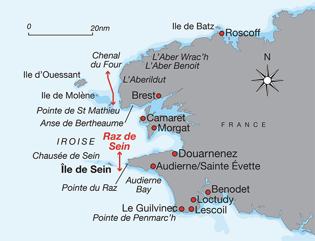
Twenty miles south of Brest, Pointe du Raz sticks out into the Atlantic and a long reef, the Chaussée de Sein, extends for another 15 miles, with the Raz de Sein a two-mile-wide gap near its inshore end.
Tidal streams pour across the reef and through this gap, where the overfalls can be severe.
Standard advice is that wind-against-tide conditions may be hazardous and a passage through should be undertaken at slack water.

Sailing across the Raz de Sein on a day without big waves: the surface is turbulent but flat. Credit: Ken Endean
However, skippers who risk the Raz de Sein with the currents flowing fast are often relieved and puzzled to find it placid.
The explanation is that ‘wind against tide’ does not necessarily indicate rough water.
Overfalls are caused by the interaction of waves and currents, rather than wind and currents.
If the wind is strong and blows for long enough, it may create suitably large waves for the currents to distort and steepen, but those currents can work the same trick on swell waves, even in windless weather.
In other words, a freshening wind over a flat sea may mean that the Raz de Sein is merely turbulent, whereas a long, smooth swell is quite likely to rear up and break chaotically.
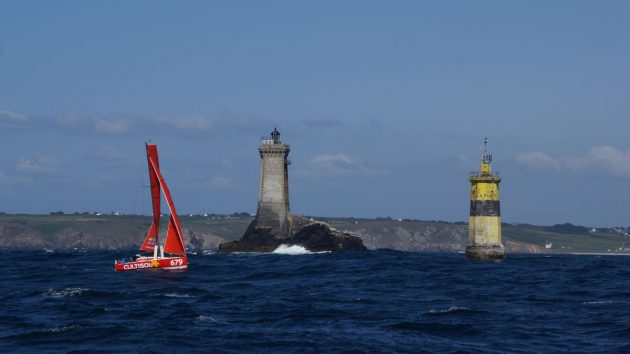
Racing through the Raz de Sein, past La Vieille lighthouse and La Plate beacon, which mark inshore rocks. Credit: Ken Endean
Atlantic swell from the west tends to wrap around the Chaussée de Sein and then swing into the Raz de Sein from both NW and SW, when wave-against-tide conditions can occur on both flood and ebb streams.
Even at slack water, the criss-crossing of swell waves may cause a very disturbed sea.
The Raz de Sein also owes part of its evil reputation to the way it is presented in pilot books and other publications, usually with aerial photos of white water tearing over the inshore rocks, which are marked by La Vieille lighthouse and La Plate beacon.
It looks terrifying but that is not the real Raz de Sein passage, which is to seaward of the beacon and less apocalyptic.
Of course, it is possible to avoid these complications by tracking out to the west and right around the Chaussée de Sein, but that could add 20 or 30 miles; most skippers opt for the inshore route.

Most yachts visiting Île de Sein anchor near to Men Brial lighthouse, although check tides as it can be shallow. Credit: Ken Endean
If the sea state in the Raz de Sein is expected to be unfriendly and the decision is to go through at slack water, it is still possible to save an hour or more by taking advantage of the complex tidal pattern.
During the north-going flood, while the main current rushes through the Raz de Sein, eddies or counter-currents begin to form downstream of Pointe du Raz and Île de Sein.
On the mainland side, the main eddy is in the Baie des Trépassés but it has several drying and shallow rock patches and can be uncomfortable in onshore winds.
On the island side, the main current is weaker and the eddy north of Île de Sein will extend south to form the first of the ebb stream, so a yacht riding on that counter-current should clear the Raz de Sein before the main tide changes.
For a yacht heading north, against the last of the ebb, the eddy south of Pointe du Raz will perform the same service and start flowing north past the point about an hour before the main stream reverses.
Heading for the sun
Many south-bound crews aim to make day sails between coastal ports and anchorages.
North of the Iroise, the narrow estuary at L’Aberildut makes a cosy overnight stop and from there a leg of about 60 miles will take a yacht right around Pointe de Penmarc’h.
In both the Chenal du Four and the Raz de Sein, the tide turns to the south at about HW Brest -0030.

The Raz de Sein at slack water but with a 2m criss-cross swell. Credit: Ken Endean
One good tidal strategy is to pass through the Chenal du Four with the last of a south-going ebb, then sail across the Iroise against weak north-going currents to catch the next ebb stream at the Raz de Sein, giving favourable currents across Audierne Bay for the next 3 or 4 hours.
The yacht will then run into a foul tide off Pointe de Penmarc’h but the prevailing wind direction is westerly and in fine summer weather the sea breeze effect often generates a brisk afternoon blow from the north west.
Continues below…

Isles of Scilly in an east wind: a pilotage guide
East winds give Ken Endean a chance to explore unfrequented parts of one of Britain’s prettiest archipelagos - the Isles…

Sailing through overfalls: how to sail safely through them
Overfalls should be respected but they don’t always have to be avoided. Ken Endean explains how to handle them
10 classic pilotage mistakes in navigation…
…and how to avoid them. James Stevens reveals the classic pilotage mistakes and explains what you need to do to…

Eyeball pilotage skills for coast crawling
Getting close in to the coast to explore a tidal channel or find a snug anchorage is rewarding but close…
An alternative plan is to carry one ebb tide from the Chenal du Four and through the Raz de Sein, then plug a contrary current across Audierne Bay before picking up the next favourable tide after Penmarc’h.
The busy fishing port of Le Guilvinec is a possible destination; three miles further east, Lesconil has a yacht pontoon.
If the weather conditions are adverse or the tide times unsuitable, there are intermediate harbours.
North of the Raz de Sein, Camaret is favourite, with Morgat offering shelter but less convenient facilities.

The inner harbour at Île de Sein has secure drying berths. Credit: Ken Endean
Between the Raz de Sein and Penmarc’h, the only well-protected port is Audierne but it has a shallow entrance.
Instead, anchor in the adjacent Sainte Évette harbour, which feels some swell but is easier to enter and leave.
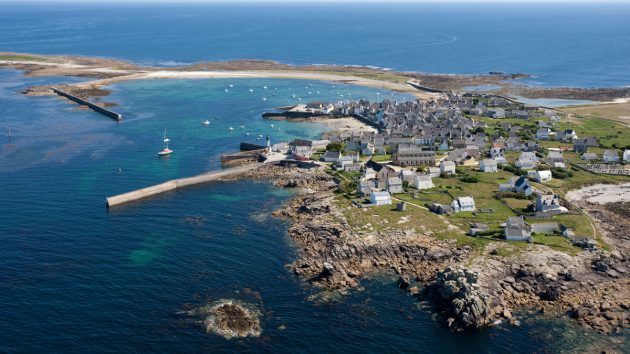
Often the most convenient harbour is Île de Sein.
It is closer to the direct track than any of the mainland harbours and is also ideal for playing the tides, because a boat that anchors at the island can depart at any time to suit the next favourable stream.
And it is a very interesting place to visit.
Island in the stream
The island consists largely of gravel banks which collected on the reef as long, curving spits that were then turned into a harbour by the addition of detached breakwaters.
A frontage of substantial houses hints at its prosperous history, with a large fishing fleet, although it is now essentially a holiday destination where narrow alleys lead between quaint stone cottages.
A couple of shops sell provisions while bars and cafés serve day-trippers.
Most visiting yachts anchor off the Men Brial light or further south, depending on height of tide.

Near Audierne, Sainte Évette anchorage has shelter from west and north. Credit: Hemis/Alamy Stock Photo
There is deeper water further north, near the main ferry jetty. The wide inner harbour dries but for yachts that can take the ground, this is the most secure anchorage.
Keep clear of the buoyed channel that leads through the approach to an inner jetty, which is used by the ferries above half tide.
Given wind from a southerly quarter, and not much swell, it is also possible to anchor off the north side of the island at the sandy bight close to the Sein lighthouse.
A passage through the Raz de Sein should pose no navigational difficulties, as there is a two-mile width of deep water.
Credit: Maxine Heath
Close to the north, the small island of Tévennec is surrounded by a half-mile fringe of shallow and drying rocks, but there is plenty of room to avoid it on either side.
Close to the south of the Raz de Sein it is advisable to steer clear of two small shoal patches.
When the sea is flat these rocky lumps induce only vigorous turbulence but when the Raz de Sein is cutting up rough this turns into particularly violent overfalls.
For tide-dodging closer to the mainland, there is deep water close to La Plate beacon.

Credit: Maxine Heath
On the island side, Le Chat beacon is helpful for south-bound craft but is close to the drying rocks and should be avoided.
The Île de Sein chartlet shows the two most useful leading lines for approaching the harbour.
These both have handy above-water rocks to supplement the transit marks in case of poor visibility or a cross-current that might disorient the helmsman.
On line A, the rock Ezaudi is a useful lateral mark and Plumbara performs the same service for Line B.
Given enough rise of tide, there is also a shortcut into the harbour, close north of the Pelven beacon.
Heading back home
On a north-bound passage in fine weather, a NW sea breeze will mean a long beat across Audierne Bay and perhaps a pause at Audierne/Ste Évette.
Anse de Bertheaume, just east of Pte de St Mathieu, is another good anchorage.
In depression-driven weather, a south-westerly wind would be fair, but if there are sizable waves or swell, the Raz de Sein will be rough until the tide swings north.
However, in winds from a southerly quarter Île de Sein is a good overnight stop and ideal for timing the next leg though the Chenal du Four, when it should be possible to carry a fair tide for up to 9 Hours, to L’AberWrac’h or beyond.
Enjoyed reading Raz de Sein: pilotage advice for cruising sailors?
A subscription to Yachting Monthly magazine costs around 40% less than the cover price.
Print and digital editions are available through Magazines Direct – where you can also find the latest deals.
YM is packed with information to help you get the most from your time on the water.
-
-
-
- Take your seamanship to the next level with tips, advice and skills from our experts
- Impartial in-depth reviews of the latest yachts and equipment
- Cruising guides to help you reach those dream destinations
-
-
Follow us on Facebook, Twitter and Instagram.