


Some hydrographic surveys date from the Victorian era. Tom Partridge uses satellite imagery as a sanity check for navigation and finds unexpected benefits

How to make navigation safer using satellite images

Tom Partridge
This feature was published in March 2016 and its information was correct at the time of writing. There have almost certainly been software or hardware developments since then.
When Susie and I set sail from the Hamble aboard our Hylas 46, Adina, we set off, like any other prudent mariner, armed with an array of paper and electronic charts together with pilot books to help ensure we could safely navigate our way around the world.
We always use our chartplotter to record our tracks, primarily as a safety feature if we need to backtrack, but also to see how accurate our charts were. What cruiser hasn’t at some stage found themselves bemused, looking at their recorded position on a chart which shows them theoretically having sailed over, or anchored on, terra firma?
We know these abnormalities exist, so why continue to rely solely on charts? Most of us carry around electronic devices loaded with maps and satellite images that we use almost without thinking to navigate our way around on land every day. On Adina we have added satellite images to our array of navigational tools and now wouldn’t consider setting sail to new destinations without having checked them first.
Your satellite imagery toolkit
Google Earth www.google.com/earth/
OpenCPN www.opencpn.org
SAS.Planet www.bitbucket.org/sas_team/sas.planet.bin/downloads
GE2KAP, C2GPXKML and other navigation tools www.gdayii.ca/Downloads/
Tutorials www.yachtvalhalla.net/navigation/terrystopics.htm
Hardware and software requirements
At present satellite navigation is best done on a dedicated laptop computer. Google Earth can be used on electronic tablets and provides real-time tracking, using built-in GPS, but lacks route planning and tracking features. SAS.Planet is not available on tablets, but there is an OpenCPN app for android devices.
Operating systems
Windows: XP, 7 and later
Mac OS X 10.6.8 or later
Linux Kernel 2.6 or later
Computer/laptop recommended requirements
CPU: Pentium 4 2.4GHz+ or AMD 2400xp+
or for Apple: Dual Core Intel Mac
System memory (RAM): 1GB+
Hard disk: 2GB+ of free space
Graphics Card: DirectX9 and 3D capable with 256MB of VRAM
Network speed: 768 Kbits/sec
Screen: 1280×1024, ‘32-bit True Color’ or for Apple: ‘Millions of colours’
GPS plug-in
Either a Bluetooth or Wifi enabled receiver, USB stick or handheld GPS with USB cord
GPS Splitter
Optional, to use one GPS input for many applications, www.gpsgate.com
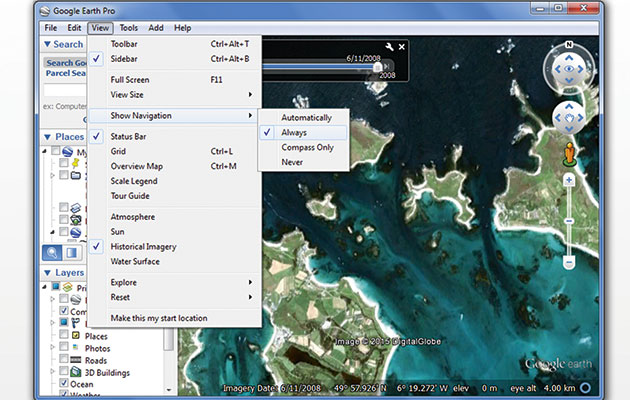
Top Tips for getting the most out of Google Earth
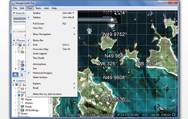
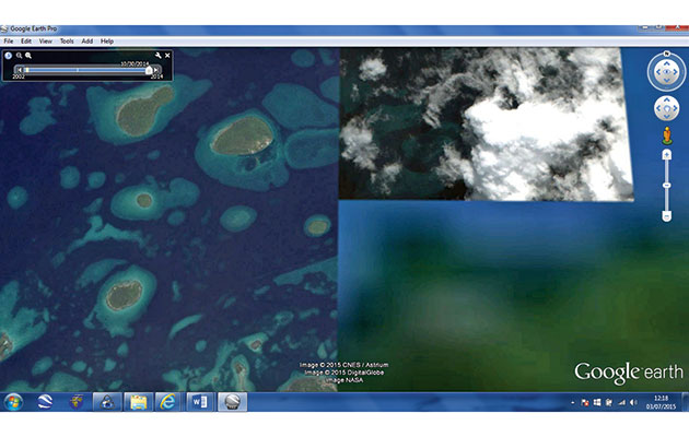
Select the ‘View’ drop-down menu. Clicking on the ‘Status Bar’ displays GPS position and image elevation information in the bottom right of the screen. Choose ‘Grid’ to get a to get a lat and long overlay, and ‘Historical Imagery’ to see older images, which may provide more detail, or less cloud cover. Use the slider in the top left of the screen to view images over time. ‘Make this my start location’ means Google Earth will open at that specific location each time
To zoom in or out, or move around, either use your keyboard or the ‘Show Navigation’ tool by selecting this in the ‘View’ menu. A moving circle on the status bar bottom right means download in progress. Make sure this is a solid blue ring before moving on! The date the image was taken is displayed on the status bar, bottom left. No date means the image is incomplete. The year at the bottom of the image is a copyright date, not when the image was taken
Remove clutter and save memory by de-selecting ‘Layers’ you don’t need in the sidebar on the left of the screen. Maximise the amount of imagery you can download to your computer by clicking on ‘Tools > Options > Cache’ and setting ‘Disk Cache Size (MB)’ to 2000MB. Google Earth will delete old or least used images once you reach this limit
Use ‘Tools > Ruler’ to measure distances. ‘Add > Path’ allows you to plot a route and ‘Add > Placemark’ lets you add a waypoint. You can save these to your computer as KMZ or KML files but may have to convert these to a GPX file for use with a navigation package
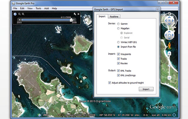
Use ‘File > Open’ to import and view routes already saved on your computer. ‘Tools > GPS’ means you can connect an external GPS device, and it’s also another way of importing saved routes, waypoints and tracks into Google Earth
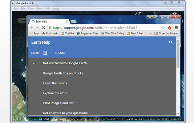
Google Earth and the tools we use to navigate with it are developing all the time. That being the case, you’re bound to have questions, and you’ll find plenty of help here – www.support.google.com/earth/
The commercial bias of charts
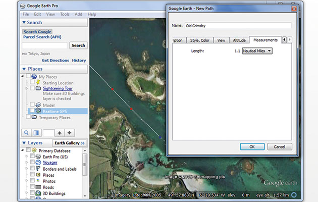
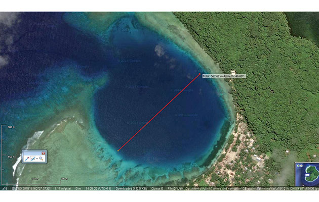
A route in Fiji’s Bay of Islands, planned with satellite images, shows charts are out by 0.56 miles
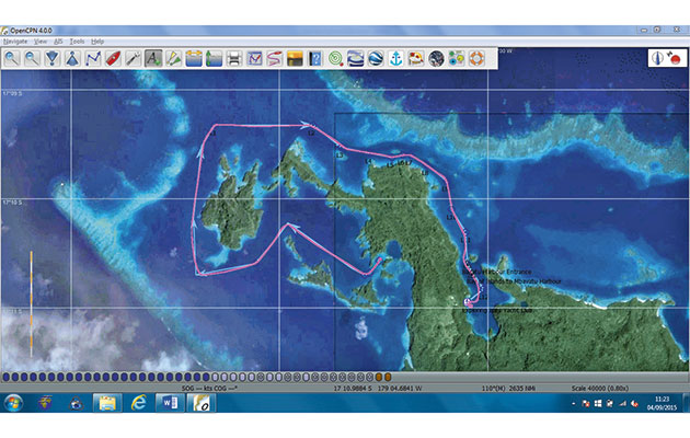
Our actual track around the Bay of Islands in Fiji shown on satellite images
As our circumnavigation progressed and we ventured to places favoured more by cruisers than commercial marine traffic we began to note more and more chart abnormalities. In this lay the explanation behind the inaccuracies: areas away from commercial ports and major shipping routes are less surveyed, commercial needs clearly driving the funding for accurate charts. In various parts of the world it’s not uncommon to find charts based on surveys dating back to well over one hundred years. These surveys were carried out using time-consuming equipment such as sextants and leadlines that have inherently lower accuracy rates than today’s hydrographic surveys, which use tools such as GPS, echosounder, sonar and radar.
Coping with surveys from 1876
When we sailed through Fiji’s remote Lau islands, an area popular with blue water cruisers, we discovered our charts were based on surveys carried out from 1876 to 1879! They were up to 0.56 miles out, a critical difference when you’re targeting a safe entrance into a lagoon. One entrepreneurial local cruiser, Curly Carswell, makes a living by providing wary cruisers with waypoints to help them navigate around the country’s many islands and reefs. We met one cruiser who admitted he was so afraid that he plugged in Curly’s waypoints and let his autopilot do all the steering.
Many of us remember the 2014/5 Volvo Ocean race incident where the Team Vestas Wind navigator reportedly failed to zoom in on the Cargados Carajos Shoals in the Indian Ocean causing the boat to be wrecked. When you compare the charts to the satellite images, the charts were actually out by just under 0.5 miles! The most extreme example we have personally experienced in our travels was Nissan Island in Papua New Guinea where the charts were a whopping 2.2 miles out. Never mind anchoring on land, the charts showed us anchored out in the open ocean.
Using technology to improve safety at sea
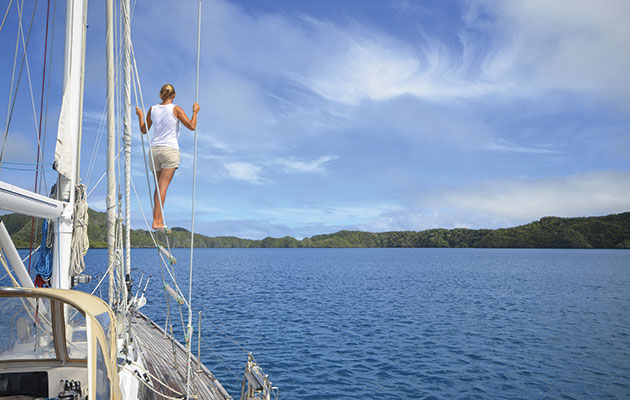
Susie stands on our conning ladder keeping a good lookout using MK1 eyeball navigation
With the Pacific Islands visibly littered with wrecks that attest to skippers having trusted inaccurate charts, we had already turned our attention to using satellite imagery. Planning ahead, in places with good Internet access, we would spend hours downloading a range of satellite images to our laptop for use offline when out sailing.
Using a GPS connection on our laptop, I can monitor our real-time position on the satellite images from Adina’s cockpit, while Susie keeps a look-out. I update her on our planned pilotage while she confirms back what she can see. ‘In 0.3 miles we will turn ten degrees to port to avoid some reef on starboard.’ ‘Ok, course is good and beyond that I can see some more reef to port.’ ‘Correct!’ We’re combining satellite imagery with Mk1 eyeball navigation to keep Adina safe.
We began to use satellite images more and more to the point where, if we could get good clear images, I would plot our routes on the satellite images before transferring them to Adina’s nautical charts for further analysis and planning.
A foolproof approach?
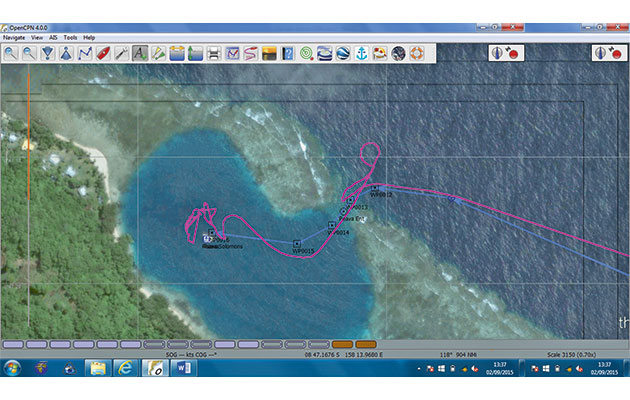
Using OpenCPN plotter software the purple line shows our tricky track into Peava Lagoon in the Solomon Islands – if we had followed the route we planned using satellite imagery we would have had no problem
When we take Adina through lagoon entrances we typically follow our route to the pass entrance and then use eyeball navigation to get us in. Good navigational skills require you to arrive with the sun positioned above or just behind you to see your way in but however good your timing after a long passage, you can’t guarantee clear blue skies.
This happened to us in the Solomon Islands where we planned to enter the Peava Lagoon through its 30m wide entrance. There was substantial cloud cover but with no strong currents or wind we progressed slowly to the entrance, eyeballing and looking for the outer edges of the pass with its lethal reef hidden just beneath the water. At the last minute we saw the reef looming to Adina’s starboard and knew immediately we were much too close to it. We had to reverse and go in again. When I looked back at our track through the pass I realised if we had stuck to my route plotted using satellite imagery we would have been bang on track.
Google Earth for navigation
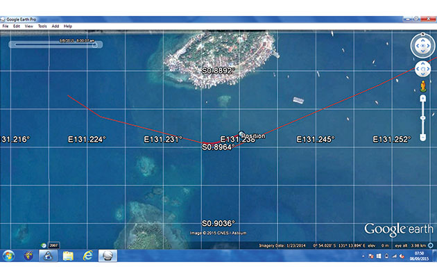
Following our position on Google Earth with GPS enabled, bound for Sorong, Indonesia
Google Earth was never designed to be used as a primary navigation tool but, very helpfully for mariners, its satellite images are georeferenced using the WGS84 datum, which is the same one used on the majority of marine charts.
Using longitude and latitude co-ordinates you can zoom in on a specific location such as a harbour or potential anchorage and can often find more detail than you can on a chart. Linking a GPS device or other NMEA source to Google Earth you can also track your real-time position as you progress. Electronic tablets or mobile phones that come with a built-in GPS will do the same thing on the Google Earth app, available free on Apple or Android devices. Google Earth on a computer offers even more features and you can add waypoints, plot routes and record your tracks.
Jargon buster
C2GPXKML
Software that converts KML and KMZ files from Google Earth or SAS.Planet to GPX file formats, which are acceptable to GPS
GE2KAP
‘Google Earth to KAP’ software that grabs Google Earth images, including latitude and longitude, and saves them as KAP files
GPX
GPS eXchange; a file format for saving and sharing routes, waypoints and tracks which contain GPS data
KAP
A file format using encoded raster images and cartographic information that can be read and displayed by electronic nautical chart programs
KMZ/KML
Key Mark-up Language; a file format used by Google Earth and SAS.Planet to save the likes of waypoints, routes, tracks and so on.
OpenCPN
Open-source Chart Plotter Navigator; free planning and navigation software developed by a team of sailors
WGS84
World Geodetic System 1984; a geodetic datum and coordinate system providing latitude and longitude positions on earth. Fortunately, it is used for electronic navigation charts and by GPS – and also by Google Earth
NMEA
The National Marine Electronics Association (of America); defines specifications that allow marine electronic instruments to understand each other
SAS.Planet
Free satellite imagery and navigation software that allows users to choose between various suppliers of electronic maps and satellite images, including Google Maps, Google Earth, Bing, Yahoo and many others
Five drawbacks of satellite imagery
Some satellite images are blurred or obscured by cloud. The time-slider top left does allow access to earlier images, which may be more useful
Before we look at the best way to use satellite images to aid navigation it is important to be aware of their limitations. It must be stressed that satellite imagery is simply one of an array of tools a diligent navigator can use. It’s not yet time to confine paper charts to the cupboard to gather dust or sit framed on the wall as a reminder of the ‘grand old days’.
The limitations can include:
1. Missing data
Google Earth focuses on providing satellite imagery for populated regions and areas of interest, and the number of updates made to the images are based on similar criteria. While most landmasses and their coasts are well represented, there are still small islands, shallow reefs and dangerous rocks that are yet to be covered in remote areas. Sea areas without satellite imagery are coloured a hazy blue. This can be misleading and it’s important not to assume it is safe, deep water. Check your charts – there may be islands, reefs or obstacles that have not yet been detailed. In time, more and more of these areas are bound to be covered. You can check Wikipedia, which tries to keep a track of areas not yet covered on its Google Earth page.
2. Image Clarity
This is one of the biggest issues. Blurred or cloud-covered images are not uncommon, making them little or no use for navigation. One potential source of help to overcome this is that Google Earth retains historical images and using a slide bar you can easily view older images, which may provide better clarity.
3. Location accuracy
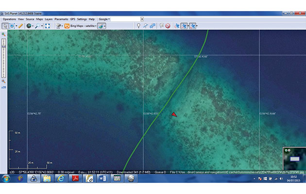
These show our track through a pass in Liapari Reef in the Solomon Islands. Bing is spot on…
…but Google Earth is 15m out
While Google Earth uses WGS84 data for georeferencing, errors do occur. We went through a narrow channel marked by posts in the Solomon Islands and looking back at our track the image was out by 15m – quite a difference in a pass that itself was just 15m wide! We queried this and Google explained that satellite images are not simply snapshots but a composite of multiple distinct frames which are then digitally combined and errors do occur. That said, this is the only error we’ve found and other cruisers we know who are also using satellite imagery couldn’t think of any examples, but do be aware of this potential issue.
4. Data size
One limitation imposed by the Google Earth program is a 2GB cache limit, which means it will fill your disk with up to 2GB of satellite imagery for use offline. Once you go over this limit it will then delete the oldest or least used information to make space for the new images.
5. Depth and other data
Good quality satellite imagery can provide greater accuracy out on the water, but it doesn’t provide soundings, nor does it necessarily show the navigation aids typically found on marine charts.
Combining satellite images with charts
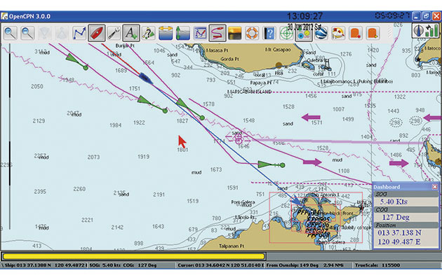
Open CPN navigation software in use on a laptop, running an AIS plug-in
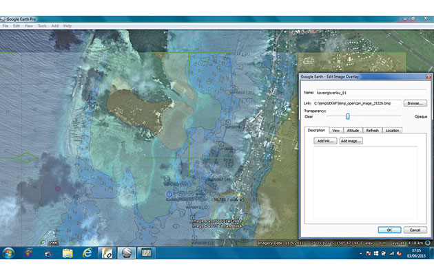
One way to overcome some of the drawbacks is to overlay the satellite images onto electronic charts to get as complete a picture as possible. To achieve this we need to save our chosen satellite images as KAP files. KAP files contain cartographic information and encoded raster images that can be read and displayed by nautical charting programs. The KAP files we want to create are snapshots of Google Earth that have been geo-referenced to enable accurate positioning on an electronic marine chart.
Fortunately for us all, there is free software appropriately named ‘GE2KAP’, developed by Paul Higgins, which will create KAP files for an area of interest as defined on Google Earth by the user. You can choose to capture a single image or multiple pictures of an area with differing levels of detail. Pointing it to a route you have created, you can define different levels of resolution for your route based on the distance between waypoints. So when nearing your destination you will typically have more waypoints with smaller distances between them and you can get GE2KAP to zoom in on these automatically and provide the increased level of detail required for safe pilotage.
And remember the 2GB restriction in Google Earth? When using GE2KAP the only limit is the size of your computer hard-drive on which the KAP files are saved. If you want, you can even share the resulting KAP files with other cruisers, perhaps earning yourself a well-deserved beverage or two come sundowner-time.
Enhancing charts with plug-ins
The next step is to check whether your navigational software can read your carefully created KAP files. Most sailors prefer to keep things simple and use a dedicated laptop with free navigation software such as OpenCPN. This software is compatible with Windows, Macintosh and Unix platforms, and plug-ins can be added according to a user’s preferences. These include AIS, radar, GRIB files, anchor alarms, weather routing and handy features like community inputs on anchorage information. Of use to us in the context of satellite navigation is that satellite KAP files can be overlaid onto charts loaded into OpenCPN. There is also a Google Earth plugin that allows Google Earth to run directly within OpenCPN, though we find this somewhat fiddly.
Correcting chart offsets
Using GE2KAP software, you can correct chart offset by moving the chart to match the satellite image
Another great feature of using GE2KAP with OpenCPN is that you can correct chart offset (how inaccurate the chart is). GE2KAP allows you to overlay the satellite image on the chart and, using a transparency slider to see both layers at once, you can move the chart so it corresponds to the satellite image. The result is more accurate charts with navigational details, which is what we want. Don’t expect perfect matches or even correct depth details all the time, as that all depends on the accuracy of the chart itself.
Different satellite images, one source
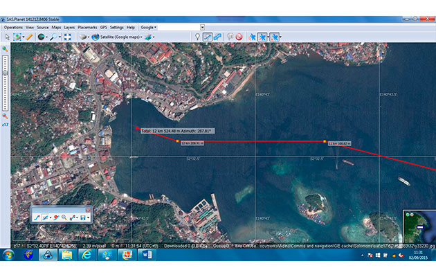
This route to Jayapura, Indonesia was planned on SAS.Planet using saved Google Earth satellite images
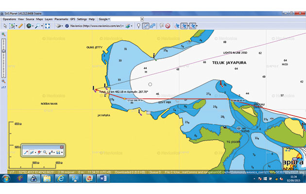
The same route on our Navionics charts would certainly have had us scratching our heads
Another satellite imagery aid is a free software tool called SAS.Planet built by Russian developers. It was not designed as a marine navigation tool but does provide some very useful features for that purpose, the key one being the ability to switch easily between satellite images from different suppliers such as Google Earth or Bing. We’ve found this a great benefit because in areas not well covered by Google, then Bing or others may have good images and vice-versa. SAS.Planet even has marine charts to view and you can download Google Maps images to use offline, handy for finding the customs office or a supermarket for provisioning.
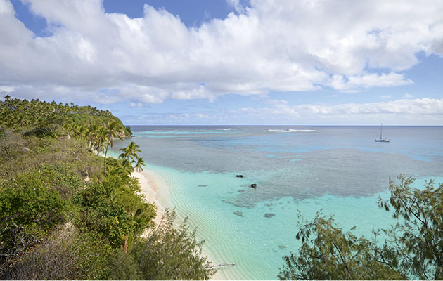
Using satellite images as part of our planning has enabled us to sail Adina to remote locations, like Kelefesia, Tonga
There is no cache limit with SAS.Planet. As with OpenCPN, you are only limited by the size of your computer’s disk and if that worries you, investing in an external hard drive can be worthwhile, as it can also be used to back up your software and data. Like Google Earth and OpenCPN, SAS.Planet has an interface that allows you to attach a GPS device so that you can see your position in real time and also record your track. Route creation is again easy but at the time of writing doesn’t offer nautical miles as a scale of measurement.
GE2KAP also interfaces with SAS.Planet, allowing you to create KAP files for use with OpenCPN so you are no longer restricted to using just Google Earth imagery in OpenCPN.
This is how we do it
All our passage prep begins with large-scale paper charts, to spot any hazards we might encounter
We start our passage preparation by looking at paper and electronic charts. Paper charts are used in high-level planning, revealing any islands, rocks, reefs or navigational aids that might be hidden in the depths of an electronic chart or not available on satellite images. We carefully read the mariner notifications that warn about reported positions being out.
With electronic charts we can create different routes to evaluate our options. Often there are useful user community edits highlighting inaccuracies, particularly the position of navigation marks.
Satellite data is next. We use SAS.Planet to look for the best satellite images of our destination. I zoom in to look for potential navigational hazards and check alternative anchorages. SAS.Planet automatically saves all the images as I go.
Endless utility
Is there enough swinging room here? We use SAS.Planet’s ruler to measure this remote anchorage on Santa Ana, Solomon Islands
Using the SAS.Planet ‘ruler’ tool, I can measure the width and length of passes or the size of a bay to ensure we will have swinging room. Planning an entry into a port, we’ll use images to pinpoint a fuel pontoon or a spot for landing the dinghy – many, many uses!
If we’re happy with what we’ve seen, we’ll plot our route and any waypoints directly on the satellite images using SAS.Planet, saving the route as a GPX file to our computer. If you need other formats, or to convert one format to another, use Paul Higgins’ free tool ‘C2GPXKML’.
To view the satellite images overlaid onto charts we use OpenCPN on our laptop. We run our saved route through GE2KAP, which automatically creates the KAP files that OpenCPN needs. You simply point it to SAS.Planet where you choose which satellite images you want. We prefer Google Earth or Bing.
Glare can be a problem when viewing laptops or tablets outdoors so we copy our saved GPX route file onto our chartplotter’s Micro SD chip. Check your own navigational software, it may use a USB stick or Wi-Fi to copy the GPX file.
If you’re short on power, the very least you need to get up and running is a dedicated laptop using OpenCPN. Use it for navigation only, because the last thing you want on your navigational laptop is a computer virus picked up from an email.
We add the same route file to our back-up handheld GPS, and our iPad for use with the weather app Weathertrack, which enables us to look at the forecast conditions for our planned route.
When that’s all done, we write up a good old fashioned passage plan – useful in case of disaster, and it also helps focus the mind to make sure we haven’t missed anything major.
This may sound a bit baffling at first but practice makes perfect and it’s soon mastered.
Off we go!
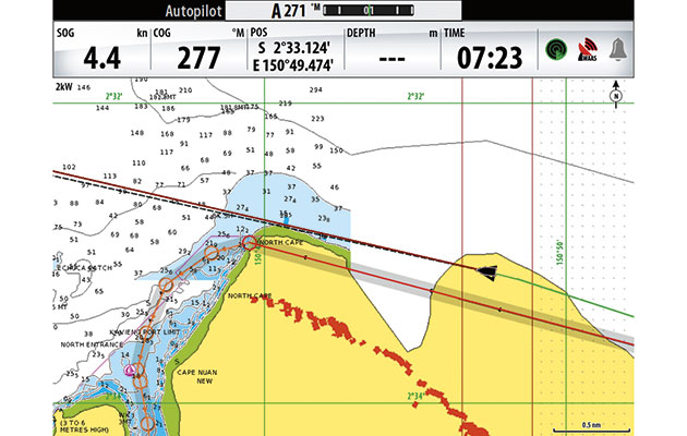
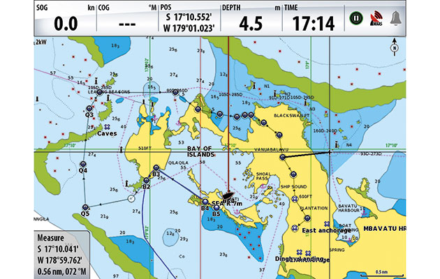
Where charting can be inaccurate, a radar overlay helps you confirm your track, based on plans made using satellite imagery, is right
When closing land we pay particular attention to radar, overlaid on electronic charts, to confirm our position and to see if the chart matches what is out there. It’s unnerving when your chart shows your route is about to take you over a headland and a relief when radar confirms you are not! That downloaded satellite image was worthwhile.
We set depth alarms to warn us about shoals – and notify us of any dolphins passing. At every watch change the person coming up checks the chart and zooms in on the route to ensure nothing untoward awaits. As we near our destination we will re-check the satellite images on the laptop to re-familiarise ourselves with our destination. But no tool is bulletproof, even radar can miss things or not provide a clear picture. At the end of the day, Mk1 eyeball navigation is still used more than any other tool we have on-board. A sundowner completes a job well done or eases the nerves after some tricky pilotage.
A valuable tool
Undoubtedly satellite images are a useful tool for any mariner seeking greater accuracy in navigation. For us, satellite imagery increases the precision with which we plan and allows us to explore more remote areas, seek more anchorages off the beaten track and ultimately delivers more rewarding cruising.
We wouldn’t think of navigating to new destinations without it. Embrace it, remember that practice makes perfect and enjoy safer navigation on your own cruising adventures.