


A katabatic wind can be sudden, strong, and unpredictable. Understanding how they work and where to expect them can help keep you safe on coastal cruises.
There are several localised metereological phenomena sailors and watersports users should know all about. Two key phenomena are land and sea breezes and Katabatic winds.
You’ll want to understand what katabatic winds are and what they aren’t so you can look out for them while sailing in coastal waters. In particular, you’ll want to be careful in areas where there are significant altitude jumps on nearby land, or when laying anchor under a sharp bluff.
Read on to find out why and add another weather and sailing skill to your arsenal.
What is a katabatic wind?
The name, which comes from the greek katabatikos meaning ‘going downhill’ or ‘descent,’ says it all.
A katabatic wind is essentially a downslope wind.

Illustration of a Katabatic wind on clear night, with flow of cool air pulled downslope by gravity.
As air cools in an area of higher elevation (for example at the top of a mountain, up a hillside, at top of a plateau, or over a cliff), it increases in density. Gravity pulls this thick, cold air down towards a lower elevation, causing it to “rush” or flow down a slope. That’s why katabatics are also considered drainage winds, or “fall winds”.
It can be much more complicated than that, but at its core that’s what a katabatic wind comes down to: cold, dense air getting pulled down by gravity.
Like thermals, katabatic winds have to do with temperature inversions, topography, air density, and pressure changes. You can even think of a katabatic wind as being a bit like the inverse of a thermal wind, since it has to do with the ground cooling instead of heating up.
What does a katabatic wind look like?

Mistral wind storm on the sea, along the coast near Cala Luna beach. Cala Gonone, Dorgali, Sardinia, Italy.
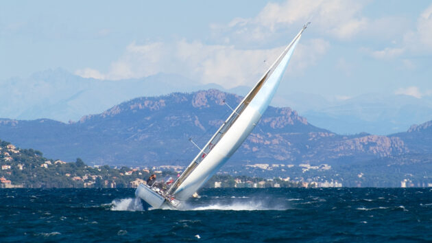
Katabatic winds can be sudden and extreme, and they won’t always come from a predictable direction. On some occasions, they can even seem to be blowing vertically. If you’ve ever gotten caught it one, you’ll know just how spooky it can be to have the sky suddenly turn on you.
These winds tend to be intense, cool, and very dry. They’re an extremely localised phenomenon that can last as little as a few minutes or as much as several days.
If you’re trying to visualise the wind’s path, remember that its trajectory is determined by gravity and topography. In this case the wind will move much like a river does, tracing down the side of a mountain side as it flows back towards the sea.

The Italian island of Marettimo just before the Mistral came in. Photo: Viveka Herzum.
When do katabatic winds occur?
Katabatic winds are more common during winter, when the temperature jump between night and day is more pronounced.
They are also largely a nighttime phenomenon. Localised katabatic winds tend to show up when the air temperature drops as it comes into contact with the rapidly cooling ground, so in the evenings, at night, and on early mornings.
How quickly they appear and how long they last depends on the particular conditions of a place. Slopes that stored more heat during the day, for example exposed rock faces, will take longer to cool. In this case, the katabatic effect takes longer to form and will likely be less intense.
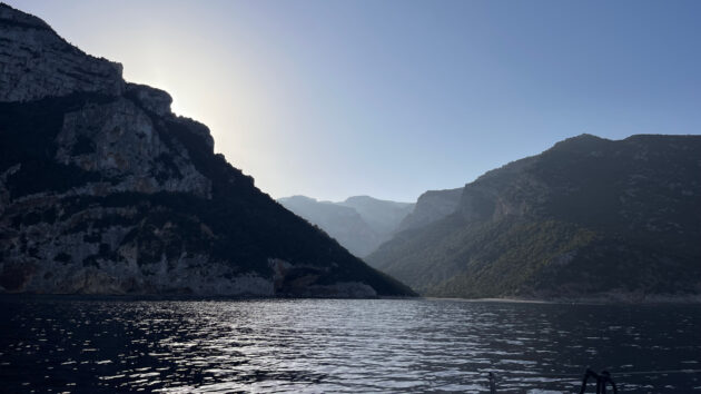
Cala Gonone, Dorgali, Sardinia, Italy. Photo: Viveka Herzum.
If you’re by glaciers, snowfields, or ice, or even if the ground is wet, then the land’s surface will cool more quickly once the temperature starts to drop. A katabatic wind can form more quickly and more intensely, as the starting air temperature is already lower.
Anyone who’s spent time in the Artic will be well acquainted with a katabatic wind’s more extreme versions. Sometimes they blow strong enough to sweep the snow right out of the valleys.

Rough Seas and High Swells due to Katabatic Winds Near Inexpressible Island, Ross Sea, Antarctica.
Katabatic winds you may have heard of…
Famous katabatic winds include the Bora (Adriatic), the Mistral and Tramontana (Mediterranean), The Santa Ana (Southern California), and the awesome Williwaw in Tierra del Fuego and Alaska. As we were saying, they are also frequent in Antartica, where they can have a decisive impact on the landscape.
While the UK doesn’t have a katabatic wind with enough regularity and intensity to deserve a name, its coastline is still subject to the same mechanism. Sudden, high-intensity drainage winds can hurtle down from over coastal bluffs and leave you reeling.
In Ligury and the Italian islands, where I’ve done most of my sailing, the northwesterly Mistral reigns supreme. Around these parts, both the Mistral and the Tramontana (Northerly) can last for several days, brushing the skies clean.

Wind-grown maritime pines in Sardinia. Photo: Viveka Herzum.
The Mistral is a great example of a large-scale katabatic effect. As the air crosses over the Alps or the Pyrenees it sinks, acquiring speed as it flows down. It gets funnelled through the Rhône valley (we’ll be talking about the Venturi effect next!) before exploding into the Golfe de Lion.
Around my parts, they say the Mistral swoops in for three-day increments. However long it lasts, you can hear it ripping through the streets, slamming shutters, stripping fields, whistling around every corner. In some places, it makes it more difficult to grow crops. In others, the trees heel over where the wind has combed through them over time.
I like to think that the Mediterranean winds have personalities, and the Mistral’s is brisk, electric, and imperious. It can be unforgiving if you’re caught unawares. Even its name carries a particular weight when spoken among sailors.

South Georgia. Fortuna Bay. Katabatic winds of estimated 7 on the Beaufort scale. on the Beaufort scale.
Difference between anabatic and katabatic winds
If a katabatic wind is a downslope wind, an anabatic wind is the opposite. From anabatos, the Greek for moving upwards, anabatic winds are upslope airflows that take place during the course of the day.
As the sun heats up the ground, the hot, lighter air rises and leaves behind an area of low pressure. Cooler, denser air flows in from the more shaded parts of the valley (or from over a body of water or masses of ice and snow). This movement creates an upwards airflow which tends to be less intense than katabatic winds.

Chapman’s Pool anchorage viewed from the South West Coast Path looking towards Weymouth.
The takeaway
If you’re sailing near mountains, make sure you keep far enough off the coast and stay prepared for a sudden wind increase. The last thing you want is to be forced into an unintentional gybe. Pick your anchorages carefully (we know you always do!), and consider electing to motor in areas where you know you’re at risk.
More importantly, familiarise yourself with local prevailing winds before setting sail. It’s always a good idea to know what you could be coming up against, and how to read the territory. Plan ahead, stay alert, and don’t let the current conditions fool you.
A katabatic wind can be sudden and extreme, but it’s no sea monster. Though on the nights when the Mistral comes in, with the way the wind howls it might as well be.
Enjoyed reading this?

A subscription to Yachting Monthly magazine costs around 40% less than the cover price, so you can save money compared to buying single issues.
Print and digital editions are available through Magazines Direct – where you can also find the latest deals.
YM is packed with information to help you get the most from your time on the water.
-
-
- Take your seamanship to the next level with tips, advice and skills from our experts
- Impartial in-depth reviews of the latest yachts and equipment
- Cruising guides to help you reach those dream destinations
-
Follow us on Facebook, Twitter and Instagram.
Note: We may earn a commission when you buy through links on our site, at no extra cost to you. This doesn’t affect our editorial independence.