


Peter Bruce discovers the rich heritage of the Hamble as he winds his way upriver

If you travel upstream on the Hamble at high water past the mosaic of moored vessels, then pass under the rather frenzied traffic on the bridges at Bursledon, the scenery soon changes to one of perfect beauty and peace.
The wide tree-lined river winds through lovely countryside and there is seldom more than the odd small craft in sight.
Few people bother to venture to this enchanting, divinely quiet location where the scenery is probably much as it was a thousand years ago.
Before the first bridge was built in 1783, access up river was possible for masted vessels, and there are several traces of ancient wooden jetties along the bank.
The wood on the left side, a mile up from the motorway bridge, is called Dock Copse which suggests its riverside usage in times past.
Nowadays one of the first features to be seen going up river, not far after leaving the last motor yacht behind on the Eastlands Boatyard pontoon, is a yellow can-shaped buoy, marked “historic wreck”.
This shows the position of the final resting place of two warships belonging to Henry V. The larger of these, the 600-year-old Grace Dieu, was commissioned in 1418, and was one of the biggest ships of her time.
She was the largest ever clinker-built ship; her length was 66m, almost as long as Nelson’s flagship HMS Victory completed 350 years later.
The impressive Grace Dieu was a bit of a white elephant, saw very little active service and burnt to the waterline after lightning struck in 1339. The other ship that lies here is the 30m Holigost.
Originally a Castillian vessel named Santa Clara, Holigost was captured and joined the English fleet in 1415. She did see active service, being involved in two naval battles which were significant English successes in the Hundred Years’ War against France.
Henry V’s victory at the Battle of Agincourt, however, meant that his navy was no longer of particular use to the nation and the Holigost was laid up and eventually sank on her moorings.

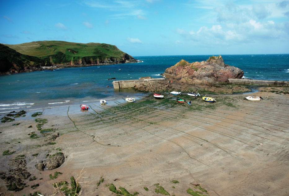
Peace and tranquility to be found up river. Credit: Peter Bruce
A third of a mile above the M27 bridge, round the first bend, the Manor Farm pontoon will be seen: a beach and a landing place are the gateway to some nice walks, picnic spots and the opportunity to see the farm and its animals at what is now called the River Hamble Country Park.
This was near the site of the secret wartime naval shore establishment HMS Cricket which was involved in amphibious craft and troops for the D-Day landings. There are still notches in the river bank left by wartime landing craft.
Onwards upriver, half a mile from the bridge, opposite Catland Copse, the river narrows a little and bends to the left and then to the right, by which time all the bustle of civilisation is out of sight. Further on, where the river turns sharply left, a beach will appear on the right which is a bathing and picnic spot.
Not far after that the river depth becomes noticeably less and the river dries out at low water, but still gives at least two metres in the channel at high water. After the next left hand bend a field will be seen ahead rather than woodland and it is here, about two miles up from the bridges, that a decision has to be made as to which tributary to follow.
The left hand one, which is the Hamble River, is navigable by dinghy another mile further up to Botley Mills, a mill since Saxon times. On the right, shortly after passing the river junction is the YMCA Fairthorne Manor boathouse.
When digging foundations for a previous boat house near this point in 1888, a Saxon log boat, made from a single oak tree, and dated around 700 AD was found, along with evidence of a Roman villa. Further on, there is one handsome private house and the YMCA camp.
Continues below…

Exploring Western Haven, Newtown
Peter Bruce packs a picnic and takes a dinghy day trip to explore a secret haven just a mile or…
Exploring Hope Cove, south Devon
This unspoilt, often overlooked haven in Devon can be a great anchorage, says Dag Pike

Newton Haven, Northumberland
Not only does this anchorage offer good holding but stargazing, birdwatching and a beautiful sandy beach, says Alastair Buchan
The river then becomes narrower with overhanging trees and is very pretty. Mallard duck are common, fish seem plentiful and there are migrant common sandpipers to be seen bobbing their rear ends whilst standing on the riverside branches.
As you approach Botley village, on the left will be seen a slipway at Botley Parish Quay. This was one of the places in use up to 1914, where goods were unloaded, such as grain, coal and building materials, which were poled up the river by barge on the tide.
Timber and flour, ground at the mill, then went downstream. Access to the slipway by motor vehicle needs the assistance of the Clerk to the Botley Parish council on 01489 787181 to pass the locked gate by the ancient Bark Store building.
Above the quay, with more and more riverside home construction taking place that seems to have assimilated the ancient wharf, the river becomes dark with overhead foliage.
A boat with any form of superstructure may find the passage tricky from here. Disembarkation is not easy until right up at the bridge over the A334 where there is a landing point for the agile.
A horizontal pipe has to be stepped over before a short, steep, narrow track leading up to the busy road near to the centre of the village.

Take a picnic and explore, suggests Peter Bruce
There was originally a basin above the bridge, used as another berthing place for barges but it has long been converted into a parking space for vehicles.
If the first bridge is left to port, the navigable river continues under another bridge a little further around Botley Mill, reaching an end where the mill head pond flows out from above the sluice gate, known locally as a ‘hatch’.
There is a landing place here which used to serve the mill but is now part of the Millstream House grounds.
Going back the mile down to the alternative river arm, Curbridge Creek, or Cur River as some call it, you follow the meandering channel through attractive woodland with a good chance of seeing herons, egrets and kingfishers in close proximity.
The navigable limit to this beautiful waterway, about half a mile up, is under the bridge a little beyond the Horse and Jockey Inn.
A boat can be tied up to the landing stage at the inn rather than parked on the gravelly little slipway and will enable the crew to enjoy good food and ale, always assuming the height of the tide will remain enough to allow passage home.
Sadly, a creature from the cetacean family, a 3.3m Risso’s dolphin, as it is now thought to have been, became stranded in the creek on 5 August 1932 and never made it back to the sea. There is a pleasant undulating public pathway along the river bank from the inn which leads to the Burridge Recreation Ground, accessible from Botley Road.
On the way down river it is necessary to leave the pontoon-moored motor yachts to port on approaching the motorway bridge, as leaving them to starboard ultimately entails doubling back.
Having experienced one of the most charming river locations in the south of England, please do not spoil it with rubbish, wash or noise. This serene hidden gem deserves to stay as it is for another thousand years.