


Take a look at charts detailing the coast of Britain to find out how the proposed Marine Conservation Zones will affect your cruising
Yachting Monthly’s
May edition featured a report on how the 189 proposed Marine Conservation Zones
around the UK coast may affect your cruising.
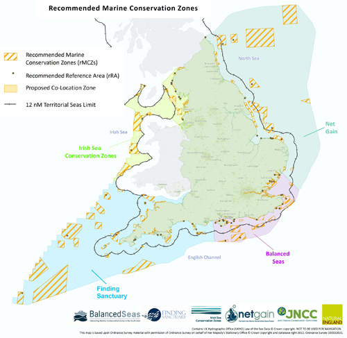
The charts we show
here give a more detailed coastal view of where the zones might be. Each chart
has been put together by the bodies set up to oversee each region’s zones -
Balanced Seas, Net Gain, Finding Sanctuary and Irish Sea Conservation Zones.
Click on each area of the map below to see a large version of the chart:
 For smartphone users, click here to view a larger interactive version.
There is also a
zoomed-in chart showing Isle of Wight and Solent waters, drawn for us specially
by Natural England, which is involved in the MCZ project in a key advisory
capacity. Please click here to see the map.
The public
consultation on the proposed zones starts in December and Yachting Monthly will
highlight before then how to get your views heard.
Meanwhile, there
is lots more information on the zones and some of the groups involved in the
debate on the following links:
Defra: www.defra.gov.uk
Joint Nature
Conservation Committee: http://jncc.defra.gov.uk
Natural England: www.naturalengland.org.uk
MCZ Project national newsletter: http://jncc.defra.gov.uk/page-2409
MCZ Project email: mczproject@jncc.gov.uk
MCZ interactive map: www.mczmapping.org
A list of marine species and habitats that MCZs will be designed to protect: http://bit.ly/zm7YLk
The Studland Bay
Preservation Association: http://studlandbpa.blogspot.com/
Information about
Lundy: www.lundymcz.org.uk
Net Gain (North
Sea): www.netgainmcz.org
Irish Sea
Conservation Zones: www.irishseaconservation.org.uk
Finding Sanctuary
(the South West): www.finding-sanctuary.org
Balanced Seas (the
South East): www.balancedseas.org